One of the key reasons we undertook this whole trip was to take
the boys to Uluru and Kata Tjuta. By
going around the outside of Australia we had missed the centre and the boys had
asked a number of times since to visit here.
So we left Wattarka (and hopefully the wind) behind and began the drive to
one of the most iconic places in Australia.
But before you get to Uluru there is an amazing place to see on
the way – Mount Conner/Artilla
You can’t drive up close or walk around Mt Conner as you can Uluru
but the view from the road is spectacular.
We learned later that Mt Conner is 3 times as big at the base as
Uluru. We also learned that Uluru, Kata Tjuta
and Mt Conner are all close to being in perfect triangle, and yet each is a
different structure, different rock and formed completely differently. On your way into Uluru make sure you stop at
the look out and observe this really amazing place.
Uluru and
Yulara
Uluru and Kata Tjuta are now in a national park – there is no
accommodation or camping in the park and you do have to pay an entry fee to
enter (we chose a 3 day pass). For this
there are a number of walks including ranger guided walks and a cultural centre
you can visit for free.
Accomodation is down the road at Yulara – a Voyages resort with a
range of accomdation options. We of
course chose the campground for our trusty Jayco Swan. It was quite large, had a good sized pool and
a viewing platform we could access from the back of our caravan site
(literally). Yulara has a range of
restaurants and activities of which we sampled many (actually more than we were
intending).
The
National Park
Over our three day pass we did a range of walks and spent several
hours exploring the Cultural Centre. The
cultural centre has some great exhibits and incorporates two aboriginal art
galleries that have a great range of paintings and wood art made by the local
people. There is also a café with
amazing views of Uluru from its windows.
There is also a gift shop which ranged from kitsch to classy.
Ranger-guided
mala walk
Park rangers
guide a daily Mala Walk (a relatively short and very flat walk). A ranger took
us along the base of the rock, stopping to tell the story of the mala (rufous
hare-wallaby) people. Along the way we stopped at several caves and the ranger
explained the cultural significance. The
rest of the way he talked about various plants and animals native to the area.
The walk runs
from - 8.00 am (October - April) and 10.00 am (May - Sept), and is an excellent
way to start your journey here as it will inform the other walks you can do by
yourself. The walk ends at the Gorge and
we strolled back to carpark taking more time in the caves this time without the
accompanying large group of people.
 |
| This was definitely a sight worth contemplating for a bit. |
Kuniya walk to Mutitjulu Waterhole
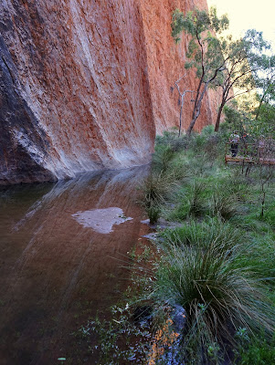
From the Kuniya carpark on the other side of the rock from the Mala walk, there is a short track to Mutitjulu waterhole, home of a wanampi, an ancestral watersnake.
Here we learnt how Kuniya and Liru (the woma python woman and poisonous snake man) helped create Uluru. The Anangu believe that Kuniya (her spirit) is still here. There are art caves nearby that apparently are still used by Anangu today. This is a beautiful and peaceful place.
 |
| See it is the heart of Australia |
Kata Tjuta
Kata Tjuta is made up of 36 domes composed of a conglomerate
rock (this means there are rocks of all sizes held together with sandstone
making it very different from the uniform sandstone of Uluru).The highest dome
546m high which makes it 198m higher than Uluru.
There are two walks at Kata Tjuta but the best by far is the
Valley of the Winds, it also the hardest.
Like the Kings Canyon walks on days over 36 this walk is shut. The day we went it was in the low 30s. BUT it is still really hot here, the rocks
radiate heat. The walk is quite long and
has some steep rocky bits (definitely wouldn’t wear thongs on this one –
although we often see tourists doing exactly that). Also take a lot of water – we had litres and
litres but still ended up using the water station 2/3s the way through to top
up.
The walk takes you to two lookouts – the Karu lookout about 1k in
and then the Karingana lookout. Karu is
pretty cool, but Karingana just knocks your socks off. If you do make it this far do yourselves the
favour and walk the rest of the track.
The path runs through the domes and is totally amazing!


MWDS
ReplyDeleteBuilding designer in Blue Mountain
Architectural Drafting Blue Mountain
Architectural consulting Blue Mountain